


Red Bull X-Alps Competition Live Tracking App uses Esri ArcGIS Platform
Esri, the global leader in location intelligence, announced today that zooom productions, a marketing agency specializing in sports and lifestyle brands, is among the latest to select ArcGIS Platform, Esri’s new platform as a service (PaaS).
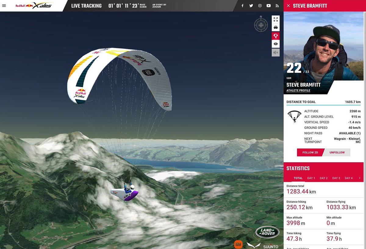
The agency has chosen ArcGIS Platform to provide Esri’s World Imagery for a custom Live Tracking app that spectators can use to watch and track athletes’ experiences as they compete in the 2021 Red Bull X-Alps competition.
Spanning five countries along more than 1,000 km (775 miles) of challenging terrain along the Alps, the Red Bull X-Alps is the world’s toughest adventure race. It sees athletes compete for almost two weeks by foot or paraglider via a fixed set of turn points. Competitors are either trail running, hiking, mountaineering or paragliding.
“Thanks to ArcGIS Platform, we can offer a better, more enriched experience for spectators,” said Ulrich Grill, CEO of zooom productions and co-founder of the race. “With the agility of the application, any fan online can see multiple views—aerial, cockpit, and 360—as if they were in the competitor’s shoes. These athletes will be venturing into hard to reach and remote areas of the Alps that few people have ever traversed. The ambition of zooom productions is to bring millions of spectators ‘into the race’, and ArcGIS Platform allows us to do this.”
Zooom’s Live Tracking app will allow hundreds of millions of fans to follow 30 competitors from 15 nations in real time using advanced GPS trackers. Esri’s topography data layers provide the high-quality imagery, mapping, and a geographic perspective needed to create a truly immersive experience for viewers of the competition.
The Live Tracking interface tells spectators everything they need to know about an athlete, including speed, altitude, covered distance, even enabling them to jump into the pilot’s seat with a virtual view. The 3D virtual reality imagery is made possible by the basemaps easily integrated using ArcGIS Platform.
The main race of the Red Bull X-Alps 2021 will start June 20 in historic Salzburg, Austria, with the route extending all the way to Mont Blanc on the French and Italian border, and concludes July 2 in Zell am See, Austria.